
Gibsons: A History
Also includes Hopkins Landing, Grantham's Landing, and Port Mellon
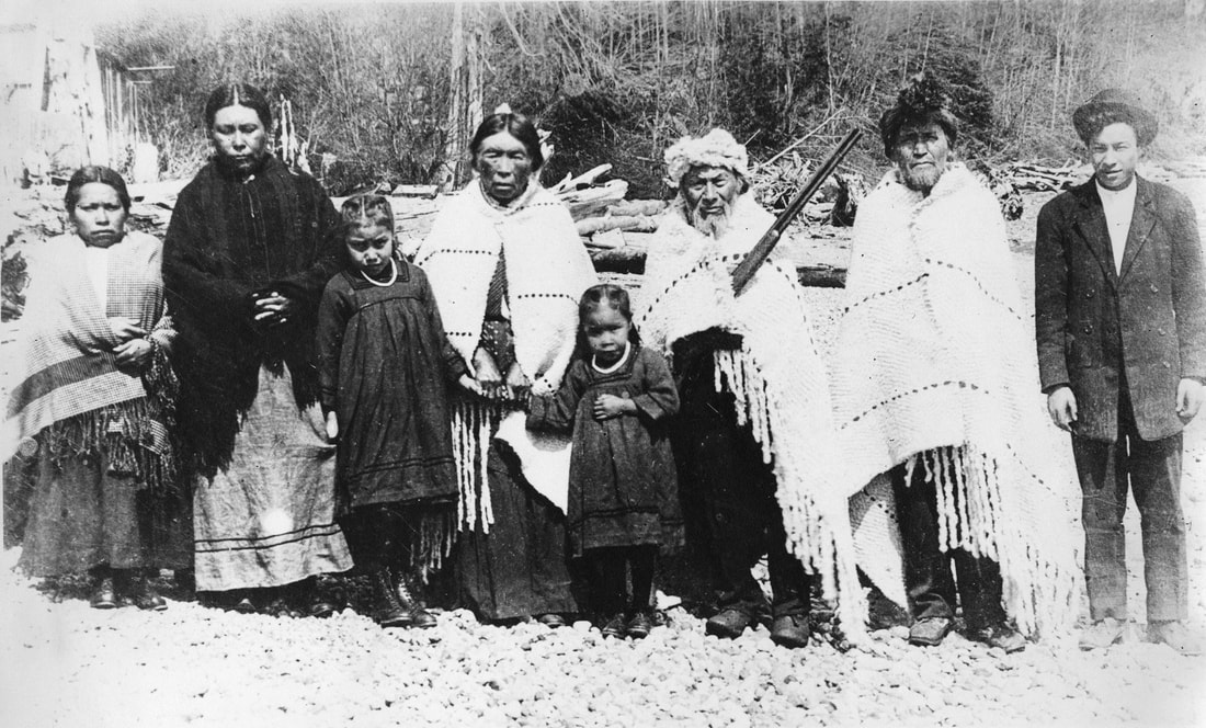
□ Residents of Ch’kw’elhp Tiyáxeltxw and Syexwáliya (centre middle) with visiting relations from Squamish, 1913. Vancouver Archives photo: AM54-S4-: LP 192.1
Skwxwú7mesh Úxwumixw (Squamish Nation)
The Skwxwú7mesh have occupied the present-day Sunshine Coast since time immemorial. Squamish stone artifacts dated upwards of 10,000 years before present represent a continuous occupation in the area, the southwest portion of their traditional, ancestral, and unceded territory.
The Skwxwú7mesh village sites of Ch’ḵw’elhp and Schen̓ḵ are located near present-day Gibsons Landing. Both locations play an important role in the Nation’s creation story, featuring brothers named Ts̓ek̲ánchtn and Sx̲eláltn, and the sacred Sx̲waýxwey dance. For millennia, Skwxwú7mesh have lived in deep connection to the rivers, forests, and mountains of their traditional territory, with place names often reflecting the importance of the land. Stone tool belongings from Ch’ḵw’elhp and Schen̓ḵ have been dated upwards of 8,000 – 10,000 years before present, representing a continuous and long-term occupation of the region. Traditionally an oral culture with ancestral names and stories passed down through the generations, Skwxwú7mesh language is called snichim, and is distinct from neighbouring Nations. [citation – Sḵwx̱wú7mesh Lil’wat Cultural Centre - https://slcc.ca/history/]
The Skwxwú7mesh Úxwumixw (Squamish People, villages and community) have a complex and rich history. Ancient connections are traced within their language through terms for place names and shared ceremony among the Salmon Peoples of the cedar longhouse. Squamish culture is rich and resilient. They continue to practice their customs and traditions, which are strongly interconnected with their traditional territory.
Today, the term “Squamish Nation” is often used to describe this group of Coast Salish people, however in the long ago there was no word for “nation” and the Squamish simply called themselves Skwxwú7mesh (pronounced Squ-HO-o-meesh) or “the Squamish People.” Skwxwú7mesh Snichim, although critically endangered, is still a vital part of the Squamish culture.
With the arrival of European setters to traditional Squamish Nation territory in the late-19th century, effects of colonialism were devastating to the Nation's rich culture, with the Indian Act and the implementation of Residential School playing a primary role.
Credit: Squamish Nation Website
Learn More: Squamish Nation website
Early European Visitation
It is generally believed that the Spanish were the first Europeans to visit the region, with maps drawn by Captains Galiano and Valdes around 1792. British Captain George Vancouver soon followed: journals kept by Vancouver suggest he went ashore near Chaster Creek. Captain Vancouver meticulously mapped the west coast’s intricate inlets and shorelines. One of the goals of his trip was to settle conflicting land claims by the British and the Spanish. With the growing expansion of colonialism in the 1700 and 1800s, small pox ravaged First Nation populations. Several local place names (Juan de Fuca Strait, Lasqueti and Texada Islands) were given by the Spanish to locations in tradtional First Nations territories.
Settlement and Pre-Emption
The settlement of certain portions of British Columbia was encouraged through pre-emption, a process that was formalized through the 1870 Land Ordinance. This allowed settlers to pre-empt (claim) large tracks of land for a nominal fee. While pre-emption benefitted the fledgling country and settlers, it was a tool used to disenfranchise First Nations from their traditional territory and occupy their land. Both First Nations and Chinese settlers were not able to pre-emp land under the Lands Act.
Gibson Family & Early Settlement
The first European to settle in Skwxwú7mesh territory near Ch’ḵw’elhp was George Gibson, an ex-British naval officer. George and his sons built the Swamp Angel and sailed to Átl'ka7tsem Howe Sound where they pre-empted (claimed) District Lot 686 in 1886.
George was born in Boston, Lincolnshire, England, January 31st 1829 (some records point to his date of birth being 1827). He retired from the Royal Navy and moved to Chatham, Ontario, where he met his wife Augusta Charlotte Purdee. They moved to BC from Ontario where he had been a successful market gardener. After a short stay in Vancouver, George and his sons built the Swamp Angel and travelled to Howe Sound where they pre-empted District Lot 686 on May 24, 1886
Within two years, Gibson had built a two-storey house, planted 100 fruit trees and cultivated four acres of land, enough to ship his produce to Vancouver to sell, and enticed other early pre-emptors including the Soames, Winegarden and Glassford families. From 1886 to 1910, much of the area was pre-empted by settlers as the population grew. Like much of British Columbia, the land was settled without treaties being signed with the host First Nations, which is why the term unceded territory is commonly used.
George Gibson was fifty-eight years old at this time but had the energy and vision to not only build his own homestead but encourage other settlers to come and live around him and form a community. Within two years, Gibson had built a two-storey house, planted 100 fruit trees and cultivated four acres of his land, enough to ship his produce to Vancouver to sell. He was very active in the community that developed, generously donating land for the school and church. He also acted as postmaster in the early years and was a jovial host to any visitors that might tie up at his wharf. The name Gibson's Landing was adopted in 1906 as the official postal address. George passed away July 11th, 1913.
Gibson's son-in-law, George Glassford, claimed the pre-emption to the north of Gibson's. He arrived the year after Gibson in 1887, and along with him came James and Emma Fletcher, who had been their neighbours in Vancouver. They pre-empted District Lot 682 on the west side of what today is Pratt Road.
The next few years saw the entire coast from Gower Point to Hopkins’ Landing, and the hinterland to the foot of Mt. Elphinstone pre-empted. In 1888 George Soames, Sr., brought his family to D.L. 694 on Howe Sound, next to Glassford and his brother, Bill, claimed D.L. 693, and Henry Blake claimed D.L. 683, just east of the Fletcher pre-emption. To the north and west of Gibson, William Manning, Arthur Hyde and John Payne took adjoining properties: District Lots 688, 689 and 590 respectively. In 1890 Arnold "Chuck" Winegarden, another son-in-law of George Gibson, settled on D.L. 1401, just north of present day Langdale.
Logging and Other Industries
The mainstay of employment for the early pioneers was related to logging and shingle bolting. Shingle bolts were four-foot lengths of straight, knot-free timber, usually cedar, used to make shakes or shingles. Originally logging was done by hand, with horses or oxen pulling the logs on skid roads to the nearest waterway. Flumes were built where this was not practical, and later truck logging completed the removal of most of the old-growth forest in the region.
Between 1900 and 1930, there were at least three lumber mills in the area, including one at the head of Chaster Creek (then Payne Creek). Lumber from this mill was transported by a flume ending in the Bay near what is now Prowse road. A charcoal manufacturing effort in what is now the Hillcrest subdivision was attempted for a few years and also the marketing of sawdust for use as a household fuel. Fishing was another means of earning a living. Gillnetters were thick in the Rivers Inlet area, and almost every Vancouver fish company had a subsidiary camp in Gibsons Harbour.
A land-clearing fire near Robert's Creek got out of hand in the hot, dry spring of 1906 and burned nearly all the standing timber as far as West Howe Sound, over five miles away. For these early pioneers, it was a frightening situation. With both good luck and determination to save their homes, only one house was destroyed and no lives were lost. The fire did, however, make subsequent land clearing a bit easier. But it destroyed the sawmill at the head of Payne Creek along with a large part of the flume, and logging on this area of the mountain did not resume for almost 20 years.
The area grew so fast, it was necessary to build a temporary log-cabin school in 1889. The following year, a school district was organized and a permanent school was constructed on the present site of Gibsons Elementary. The first classes were held on January 19, 1891 with teacher Mrs.Lucy Smith presiding over her 23 students.
Hopkins and Grantham's Landings
Two other early settlers of the Gibsons area were Irishman George Henderson Hopkins, who bought a 160-acre site in 1906 that later became Hopkins Landing, and F. C. Grantham, a Vancouver businessman, who built a summer cabin on an 800-foot stretch of waterfront in 1909. He added roads, a water system, a floating wharf, plank sidewalks and 25 cabins on the beach, attracting boat loads of summer vacationers. He called his resort Howe Sound Beach, but after a government wharf was built there, it came to be known as Grantham's Landing. The locals sold much of their farm and dairy produce to the resort.
Finnish Pioneers and the Socialist Movement
In 1905, an influx of Finnish immigrants moving from Sointula, the socialist utopian community on Malcolm Island, made an impact on the Gibsons Heights area. They industriously farmed the flat land on the bench above the waterfront and organized two community halls (the Workmen's or Labour Hall and the Socialist Hall), and took part with other local farmers in founding a local branch of the Farmers' Institute and running a co-op store. The Wiren family was one of the early Finnish families who settled in the region with Wiljo Wiren being a prominent community member through the years.
There was some tension in the community between these "foreigners" with their socialist views and some of the more conservative pioneers. The local Methodist minister, James Shaver Woodsworth, who arrived in 1917, found himself in sympathy with the Finn's socialist, anti-war philosophy. Woodsworth organized a series of forums on events of the day which were enthusiastically attended by most of the area's residents, and where the merits of socialism versus "free enterprise" were often hotly debated.
Gibsons Landing's first doctor was Frederick Inglis, who held a degree in both medicine and divinity from the University of Manitoba. He arrived in 1913 with his wife Alice and six children, and built Stonehurst, his home and clinic overlooking the harbour. For the next 33 years, except for a brief period during the war, he was the only medical practitioner from Port Mellon to Halfmoon Bay. He served his patients by rowboat, horse and later a Model T Ford. Inglis was also an enthusiastic supporter of socialist beliefs, and helped organize the Elphinstone Co-operative Store. At one point, he took Mrs. Woodsworth and their six children to live with his family at Stonehurst when James Woodsworth was forced to seek work in Vancouver after resigning his position as Methodist Minister in protest of the Church's support of the War.
Howe Sound Cannery
Much of the area's farmland at this time was dedicated to growing raspberries, strawberries and other berry crops. After the war, there was a glut of berries on the market. The West Howe Sound Cannery Association was formed in 1921 and later the Howe Sound Cannery was opened to process the abundance of fruit. Over 150 shares were sold, and the cannery provided a market for small farmers all through the depression of the 1930s and the following war. Changing markets and lack of cheap labour forced its closure in the early 1950s.
Howe Sound Pulp & Paper
The British Columbia Wood Pulp & Paper Company was established in 1908 by Captain Henry Mellon at the mouth of Rainy River at Port Mellon. The mill changed ownership several times during the century, in 1927 becoming Howe Sound Pulp & Paper Mill, still in operation today. To divert the hard-working mill men and other holiday makers, Seaside Resort was built by Charles Henry Cates on the other side of the river from the mill. After the construction of a road from Gibsons to Port Mellon around 1950, the Mill became one of the largest employers for Gibsons residents, and the resort and a once-thriving company town at the mill site, have now dwindled to a few scattered dwellings and a tiny public garden.
Later Development
Until after World War II, Gibsons and area remained a small rural community based on Logging, Fishing and a limited amount of agriculture. In 1951 a car ferry service, Black Ball Ferries, later to become BC Ferries, was started, and for the first time it became relatively easy to travel between Gibsons and the Lower Mainland by car. In the next few years, the roads between the various communities on the Sunshine Coast were paved and improved which encouraged commerce between these areas as well as with Vancouver.
At this point, growth became much more rapid. A new high school was constructed at Gibsons, and shortly after, the area's first Supermarket. Both of these buildings were located on the flat land at the top of the hillside, an area that was part of the old farming district where flat land allowed expansion and adequate parking compared to the old business area around the wharf at the waterfront. This trend in development continued, and now today most commercial activity is located in "Upper Gibsons" while the waterfront has become more of a tourist and cultural area.
_____________________________________________________
Sources:
The Gibson's Landing Story, by Lester Peterson
The West Howe Sound Story, by Francis J. Van Den Wyngaert
J.S. Woodsworth, A Man to Remember, by Grace MacInnis
Various documents from the Archives of the SCMA